


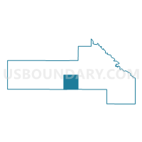
Swede Prairie Twp. Voting District, Yellow Medicine County, Minnesota
About
Outline

Summary
| Unique Area Identifier | 605025 |
| Name | Swede Prairie Twp. Voting District |
| County | Yellow Medicine County |
| State | Minnesota |
| Area (square miles) | 36.22 |
| Land Area (square miles) | 36.21 |
| Water Area (square miles) | 0.01 |
| % of Land Area | 99.98 |
| % of Water Area | 0.02 |
| Latitude of the Internal Point | 44.68284070 |
| Longtitude of the Internal Point | -95.90116990 |
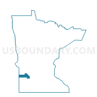
Maps

Graphs
Select a template below for downloading or customizing gragh for Swede Prairie Twp. Voting District, Yellow Medicine County, Minnesota


Neighbors
Neighoring Voting District (by Name) Neighboring Voting District on the Map
- Burton Twp. Voting District, Yellow Medicine County, MN
- Eidsvold Twp. Voting District, Lyon County, MN
- Friendship Twp. Voting District, Yellow Medicine County, MN
- Normania Twp. Voting District, Yellow Medicine County, MN
- Omro Twp. Voting District, Yellow Medicine County, MN
- Tyro Twp. Voting District, Yellow Medicine County, MN
- Vallers Twp. Voting District, Lyon County, MN
- Westerheim Twp. Voting District, Lyon County, MN
Top 10 Neighboring County Subdivision (by Population) Neighboring County Subdivision on the Map
- Eidsvold township, Lyon County, MN (236)
- Westerheim township, Lyon County, MN (235)
- Vallers township, Lyon County, MN (214)
- Friendship township, Yellow Medicine County, MN (192)
- Normania township, Yellow Medicine County, MN (191)
- Tyro township, Yellow Medicine County, MN (181)
- Swede Prairie township, Yellow Medicine County, MN (170)
- Omro township, Yellow Medicine County, MN (161)
- Burton township, Yellow Medicine County, MN (148)
Top 10 Neighboring Unified School District (by Population) Neighboring Unified School District on the Map
- Yellow Medicine East School District, MN (7,006)
- Dawson-Boyd Public School District, MN (3,021)
- Lakeview School District, MN (2,735)
- Minneota Public School District, MN (2,589)
Top 10 Neighboring State Legislative District Lower Chamber (by Population) Neighboring State Legislative District Lower Chamber on the Map
- State House District 21A, MN (36,793)
- State House District 20B, MN (34,629)
- State House District 20A, MN (32,187)